Where is Sherman Park?

|
The Sherman Park neighborhood is on Milwaukee's northwest side. North of North Avenue, West of Fond Du Lac Avenue, and East of Sherman Boulevard.
|
What is the Exact Site of Analysis?
|
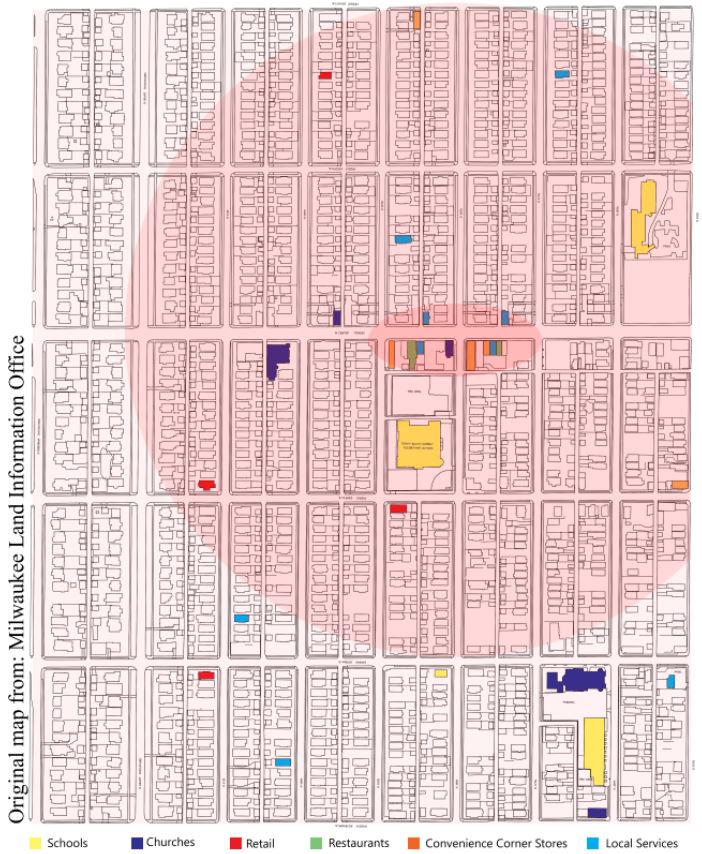
I am specifically focusing on the main street section of Sherman park, which I defined as this small grouping of commercial buildings in the center of the neighborhood. As I first started to look at this block, I decided I really wanted to work on a vacant lot, between a convenience store, and abandoned building on Center Street. It was a great opportunity to use existing architecture to my advantage for my future design project.
|

|
Sherman Park Assets Compared to Another Neighborhood's Assets:

|
What I did, in this comparison, is find assets in 6 different categories within a two-block radius of Sherman Park's main street, and then compare that with another Milwaukee neighborhood's assets. The goal was to prove that the architecture in Sherman Park has not been invested in nearly as much as it should be. Within two blocks of the "main street block" of Sherman Park, I found numerous convenience stores, while there was a complete lack of real restaurants or local services (like barbers and banks).
Compared to the "main street block" of the Shorewood neighborhood (also here in Milwaukee), which I defined as the intersection of Capitol St. and Oakland Ave, Sherman Park was far outnumbered in assets. Shorewood, within only two blocks, had sixteen local services and over ten restaurants. As I also expected, Shorewood had far less convenience corner stores, which often sell unhealthy foods and alcohol. This leads me to believe that for neighborhoods of similar size, one is at a clear disadvantage and is unjustly at a level where nicer restaurants or services do not want to start up, even though there is a demand for them. The area is practically a food desert. |
